NDVI Drone
Take The Temperature of Your Golf Course.
NDVI imaging provides an in-season checkup. Normalized difference vegetation index (NDVI) is an indicator that can be used to analyze live green vegetation.
Checkups with your doctor are designed to avert a major health issue. Thermal imaging does the same for your golf course.
To determine a field’s stress level, look at an aerial photo that shows the variance in ground temperature. A cooler area is less stressed; the warmer the ground area, the more it is stressed.
We’ve been able to use color photos, NDVI maps and now thermal images as scouting aids and as tools to help define and refine management zones.
NDVI imaging is just emerging as a tool for golf courses because the high-tech camera equipment that’s required is now available.
NDVI cameras measure the energy emitted by the vegetation to produce infrared images, which are then processed to apply the scaling to show the variation in the area. The cameras can work just as well in the darkness of night. NDVI maps show a measure of ground area health with near-infrared images that rely primarily on reflected light from the sun and amplify changes in color.
Our camera has the ability to decipher differences of up to three-hundredths of a degree Celsius. The thermal image is then scaled down to a narrow temperature spectrum and a color palate is applied to assess the variation.
With these images, you can see the problem areas of the golf course, and then go out and address these specific areas. This information will help assign different levels of fertilizer, irrigation and pesticides.
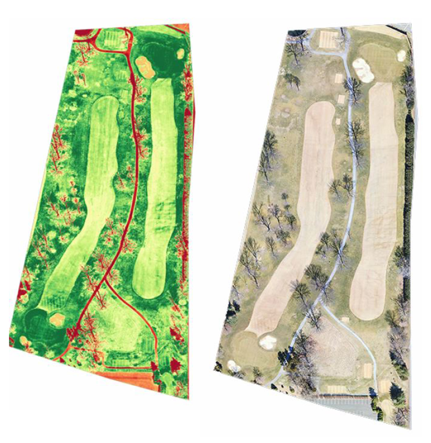
The green shows the healthy areas of the course. The yellow areas document the unhealthy areas that need attention. The red areas show vegetation dormancy, roads, dirt and buildings.
Better Golf Course Management with NDVI Drone Services.
Golf course management is the art of using tactics, environment know-how, resources, and science to make golf courses great. It doesn’t matter if the golf course is public, private, or members-only, all need attention to stay in top condition.
Drones are now a popular way to gain aerial info about the turf on any golf course. This data is used for NDVI (Normalized Difference Vegetation Index) analysis. This helps owners/managers get a detailed view of any issues and the solutions to fix them.
The drone tech analytics shows turf health and ecological issues like weed control, disease risk, and water use. It lets owners/managers keep an eye on their golf course’s condition.
Benefits of Using NDVI Drone Services
Drone-based NDVI services provide huge advantages for golf course management in comparison to traditional field surveying techniques. AI, advanced optics and machine learning algorithms make it possible to quickly discover areas of overgrowth, turf disease, and water distress. This enables efficient and effective strategies for golf courses.
Accuracy and time savings are improved compared to traditional methods. NDVI services use aerial footage from a multi-spectral camera. This gives readings on a single plant species level, not the coarser readings from ground-level surveys. Therefore, data is more precise. Plus, it can be acquired faster, saving lots of time surveying large golf courses.
Detailed maps with info about issues in specific locations can be made. NDVI services can produce detailed mosaic maps to show changes in vegetation health. They can do this for all kinds of plants across an entire golf course or specific areas. Plus, the high-resolution images supply data for overlapping maps. This gives insight into areas needing maintenance.
Customized management solutions are enabled based on data gathered from accurate assessments. Golf course operators can get critical info like water penetration points. They also benefit from tailored irrigation scheduling, fertilizer applications and overall health predictions. With this precision, they can identify sections where harsh chemicals are suited, saving time and money compared to wider area treatments.
Overview of NDVI Drone Services
NDVI Drone Services are a great way for golf course managers to observe their courses from the air. NDVI stands for Normalised Difference Vegetation Index. It enables instant visibility of various aspects of the golf course, such as turf health, growth, and management.
High-resolution aerial images and green-spectrum filtered photos are combined. Golf course professionals or superintendents can easily compare vegetation between holes. They can even find out about diseases or pests affecting specific greens. Having this knowledge helps to make decisions about fertilizers, fertilizer combinations, soil health testing and other environmental issues.
NDVI Drone Services also provide data to measure the effectiveness of turf treatments. The data can show changes over weeks or months. With this data, golf courses can make sure they are in top condition. 1836 Drone Services help to make decisions backed by data.
How to Implement NDVI Drone Services
Golf course managers can use NDVI drone services to gain insights into turf health and reduce costs. They collect data from certain areas of the golf course, such as temperature, moisture levels, and soil type. This data helps them make decisions about things like fertilizing, pest control, and maintenance schedules.
To utilize NDVI drone services, these steps should be taken:
1. Research the NDVI drone service providers that best fit your needs. Consider accuracy, customer service, and product guarantees.
2. Define the output you want from your drone missions. Think about factors like altitude, distance between each photo, etc.
3. Identify areas of the golf course that need to be analyzed. Plan a mission outline for each zone or segment.
4. Fly the mission according to safety regulations, with certified personnel controlling the drone. The NDVI equipment captures aerial imagery for post-flight processing. This includes soil type analysis, monitoring of pest damage, etc. The mission typically takes 7-8 minutes to complete, depending on the plot size. FAA regulations must be followed.
Factors to Consider When Choosing NDVI Drone Services
When selecting a drone surveillance service for golf course management, there are several important factors to consider. NIR technology, and NDVI or Normalized Difference Vegetation Index, can be used to monitor turfgrass health. Here’s what to look out for:
1. Verify the area being monitored is fully covered by the drones. Check that they can capture NIR infrared images at regular intervals.
2. Make sure the data quality is high enough to identify healthy growth conditions for grass.
3. Compare costs of different providers and make sure you get value for money.
4. Check how quickly the drone provider processes and delivers data. This will help with budgeting and improve efficiency with turf management decisions.
Challenges of Golf Course Management
Golf course managers face challenges of limited time, manpower, and data collection when it comes to maintenance tasks. But, drones and NDVI imaging are here to help!
Drones can provide golf course management teams with the efficient solutions they need. NDVI inspections give them real-time data in minutes, compared to days with traditional methods. Plus, this technology can help with water conservation and precision fertilizer application.
In short, NDVI drone services help managers reach greater efficiency and cost savings.
Best Practices for Golf Course Management
Golf courses are much more than just well-manicured lawns – they are complex businesses. Asset management is key for a successful business and courses can benefit from understanding best practices. Golf course managers have many tasks to stay on top of and no room for mistakes.
Aerial imagery, used with drone services, can reduce labor costs. Turf-related issues can be quickly identified, saving time. Course staff can be used in other areas while the drone flies. This also creates environmental benefits with less fuel needed.
Real-time data from drones allows for tracking turf health. NDVI (Normalized Difference Vegetation Index) supported systems provide diagnostic capabilities, predictive analytics, fertility management, and water management.
Golf courses can reduce costs with optimized workflow processes and more efficient inspection cycles. This means less green fees or memberships.
Conclusion
By utilizing near-infrared drone services, turf managers can map golf courses and identify weak spots. This tech provides an efficient, accurate way of mapping courses and reducing issues. It gives detailed info on course conditions.
Data from this tech can help maintain the course. Managers can track health more often to create healthier areas, cut down on disease, use water efficiently, and optimize fertilizer/pesticide applications. It also improves playability.
Near-infrared drone services are a major breakthrough in golf course management. It gives turf managers insights and helps increase productivity while saving costs.
Mike Haller
stlouisdronephotographer@gmail.com
314-892-1233
